
If you would like to learn more about the IAEA’s work, sign up for our weekly updates containing our most important news, multimedia and more.
Scientists study ‘invisible rivers’ to manage extreme weather and water scarcity
Katrina Vargas
Just as rivers flow across the land, sustaining communities, livelihoods and biodiversity, ‘invisible rivers’ flow above us, carrying more water vapour than all the rivers on Earth combined. These moisture highways — known as atmospheric rivers — have a tremendous impact on weather and rainfall patterns globally. ?
Climate change and human activities are influencing the behaviour of atmospheric rivers, shifting their paths and causing extreme weather events such as floods, storms and droughts. Studying isotopes in atmospheric rivers can help us understand and track them, thereby improving weather forecasts and predictions of extreme weather events.
What are atmospheric rivers?
Atmospheric rivers are naturally occurring bands of concentrated water vapour thousands of kilometres long that course through the Earth’s atmosphere. They form when intense heat from the sun evaporates ocean water along the Equator. Winds carry the water vapour towards the poles, creating ‘rivers in the sky’, which usually flow no higher than 3000 metres above ground — about one third the height of Mount Everest. When they reach coastlines, atmospheric rivers are pushed upwards, and as they approach mountains, they release moisture in the form of rain and snow.
Atmospheric rivers provide vital freshwater to many parts of the world, especially in coastal regions. In California, on the western coast of the United States of America, atmospheric rivers account for about half of annual rainfall, filling reservoirs and supporting farmers. They also account for between 30% and 60% of annual rainfall on the coasts of eastern China, the Korean peninsula and western Japan.
Pressures of climate change
As global temperatures rise, more moisture accumulates in the atmosphere, leading to more intense and frequent precipitation from atmospheric rivers. This phenomenon is responsible for more than 80% of heavy rains in many coastal regions in East Asia.
“As the climate warms, extreme weather events are becoming even more intense, and many are driven by atmospheric rivers,” said Julie Kalansky, Deputy Director of the Center for Western Weather and Water Extremes at the Scripps Institution of Oceanography.
At the same time, atmospheric rivers are moving away from the Equator and toward the poles. They are becoming less common in subtropical regions, which now face reduced water supply and drought, while places like the Pacific Northwest, Europe and the Arctic are seeing heavier rainfall and flooding.
The role of isotopes
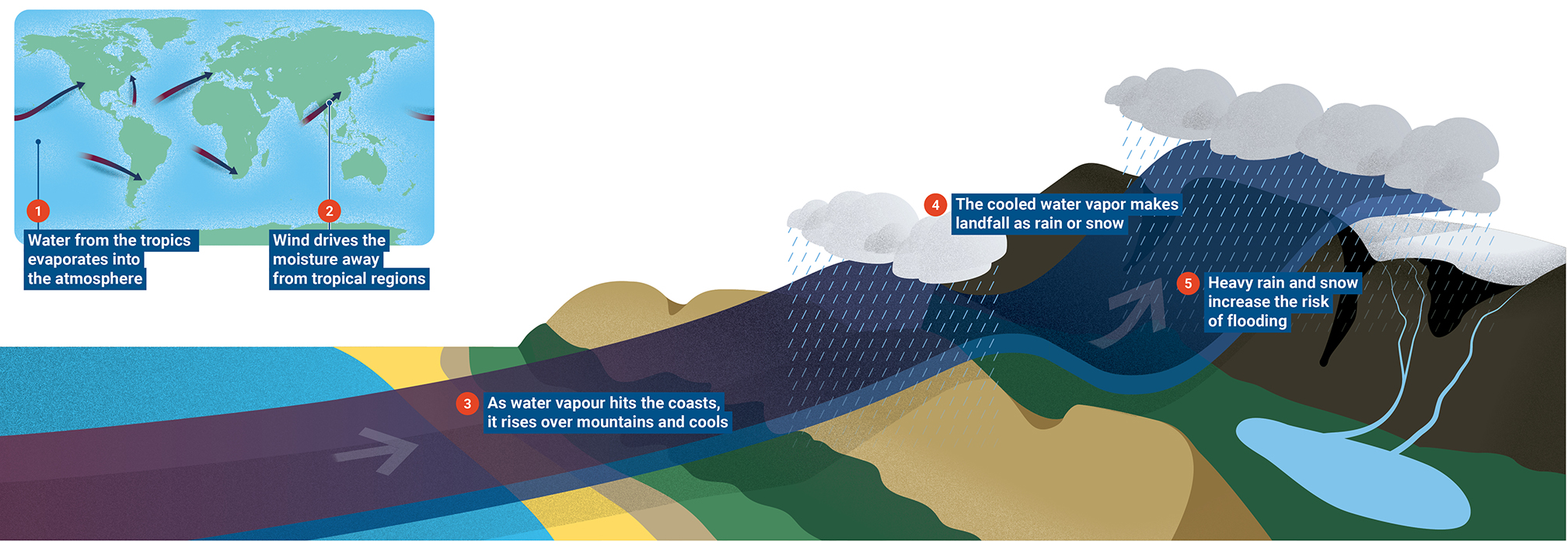
“Atmospheric rivers are highly variable year to year, making it difficult to predict how much rain we’ll get each year,” said Kalansky. “This unpredictability of seasonal precipitation poses major challenges for managing water supplies.”
Scientists are using stable isotopes — non-radioactive forms of atoms — to study how climate change impacts atmospheric rivers. The techniques trace where water vapour comes from, how far it has travelled through the atmosphere, where it falls as precipitation and how it interacts with the water cycle. This information can be used to anticipate extreme weather events and reduce their impact, identify flooding risks and manage water resources, especially during drought.
A new IAEA coordinated research project is integrating isotope tracers into hydrological and climate models to track and simulate how different forms of water move and change throughout the water cycle.
“The data we will gather through the research project can help assess the increasing risks of flooding, droughts and water scarcity,” said Jodie Miller, Head of the IAEA’s Isotope Hydrology Section. “It can also help countries develop strategies to mitigate risks, improve water management and enhance climate resilience.”
“We are using data on water vapour isotopes to improve the accuracy of weather forecasts,” said Kei Yoshimura, a professor at the Institute of Industrial Science at the University of Tokyo, who is participating in the project. “Especially useful in mid-latitudes, isotopic data will help better predict moisture transport and rainfall patterns linked to atmospheric rivers.”
The project draws on 65 years of data from the Global Network for Isotopes in Precipitation (GNIP), which tracks precipitation at over 1000 monitoring stations worldwide. GNIP data can be used to analyse the origin, pathways and precipitation patterns of atmospheric rivers, offering insights into their changing behaviour in a warming climate.